Kaohsiung’s Hiking Trails
Kaohsiung’s Hiking Trails
◎English translation: Hou Ya-ting
◎Photos by Sie Sin-jia, Bill Hwang
 Kaohsiung has a lot of natural areas that are just waiting to be discovered. Hiking has become a popular activity and various trails can be found throughout Kaohsiung. Scenic trails can be found in several districts, where visitors can also explore various historical sites.
 Cijin District
Cijin Island is a wonderful tourist destination. People flock there to bask in the sun and have a fun day at the beach. It can be reached in only a few minutes by ferry that runs from the Gushan Ferry Station. It is always fun to take the boat over to one of Kaohsiung's most traditional districts.
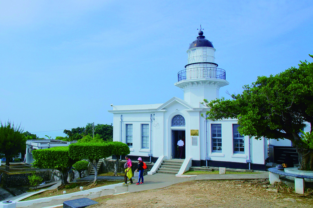
When the ferry arrives at Cijin Ferry Station, walk towards Tianhou Temple at Cihou, which can be found at the end of Tongshan Road (the district's bustling main street). The end of the road will bring visitors to the foot of Cihou Mountain. Find the Cihou Lighthouse and fort entrance and walk uphill along the s-shaped path. Visit the lighthouse, which has been guiding ships around the Port of Kaohsiung since 1918. It features fantastic views of the ocean, Sizihwan Bay and National Sun Yat-sen University.

Zuoying District
Banpingshan is a tranquil oasis in the middle of city and is located between Zuoying and Nanzih. The entrance is located on Cueihua Road. Follow the wooden path to the scenic lookout, where the path splits. Both trails ascend the 223-meter mountaintop. Great views of Lotus Pond and Dragon Tiger Tower can be seen from the peak. The Main Stadium can also be seen from its most westerly point.

Gangshan District
The 251-meter high Siaogangshan (Mount Siaogang) is situated east of Gangshan. It was once a military base and was previously prohibited to the public. In 1987, when martial law ended, it was subsequently opened up. Visitors can now visit the military block house and other military sites.
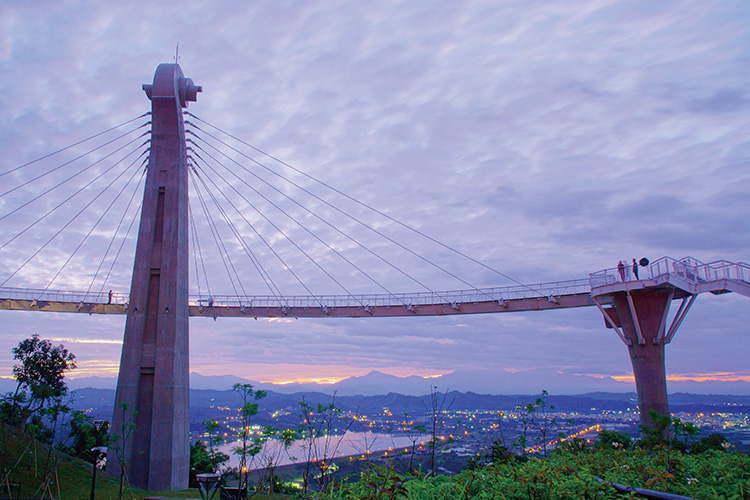
The Agongdian Reservoir can also be found on Siaogangshan. The entrance of the Siaogangshan trail is located in Agondian Forest Park. Visitors can park in the Agondian Forest Park’s parking lot and walk a few meters along Shueiku Road to find trails leading up to Siaogangshan Skywalk Park. These include the Lising, Zihciang and Haohanpo paths. Siaogangshan Skywalk Park is an 40-meter high, 88 meters long, new suspension bridge and the city's most recent attraction. It is the best place to view the Agongdian Reservoir. It also has spectacular views of the Port of Kaohsiung and the Kaohsiung Sky Tower. On a clear day, Mount Dawu in Pingdong can also be seen from a distance.

Dashe District
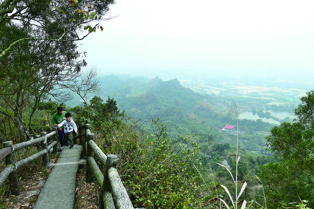
Mount Guanyin has a variety of hiking trails. Hikers, who prefer easier trails, should take the Dajyue Temple entrance, which will lead them to Ecological Park. Those who prefer more physically challenging trails can take the quickest route to Mount Guanyin's peak, by entering through Fongyi Temple's 500-step stone staircase. At the top, there is a pavilion and a military tunnel that was built during Japanese colonial rule. There is also another lookout adjacent to the main peak, which provides panoramic views of Kaohsiung. On a clear day you can see as far as Anping Harbor in Tainan.
Some may choose the greater physical challenge of the Mount Jian trail. Spectacular views of Monkey and Camel Mountains can be seen near the rear of the main peak. The climb is rather steep but ropes are provided. However, it is a rather strenuous trail; therefore, one should be in good physical condition before venturing onto the more advanced trails.

Tianliao District
80% of Tianliao District is covered by mudstone badlands. Due its magnificent topography, it has been nicknamed, “Moon World.” In 2014, Kaohsiung City Government's Tourism Bureau established Tianliao Moon World Park.
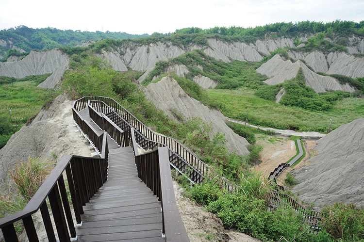
Visitors can visit the Moon World Tourist Center, which is located at the front entrance. The visitor center provides information about the region's ecology and terrain. They also give tours and advice on self-guided trails. The Circumnavigated Lake Hiking Trail and Wulikeng Walkway are located at the front and back entrances. To appreciate badlands, follow the trail to Circumnavigated Lake Hiking Trail and then follow the signs. There is spectacular scenery all the way up to Jade Lake. Continue along 156-step walkway to the Moon World lookout. It is a circular route that will eventually lead back to the entrance. The Wulikeng route takes visitors approximately 400 steps through the back of the park and also provides fantastic panoramic views.

Yanchao District
In Yanchao district, visitors can climb the 200 meters Rooster Crown Mountain. Its name was derived from the summit resemblance of a rooster crown. The hiking trails begin at the Jinshan Convent and Chen's Historical House. There are two trails, which both end up at Jinshan Elementary School. Although it is a shorter trail, it requires a rope to get to the peak. Hikers can enjoy stunning regional scenery, with the peak offering views of the Agongdian Reservoir, Siaogang, Dagang and Jhongliao Mountains.