Ta-di Mountain Natural Park in Mituo District / 彌陀漯底山
Ta-di Mountain Natural Park in Mituo District
◎English translation: Marie-Claude Pelchat ◎Photos by Pao Chung-hui
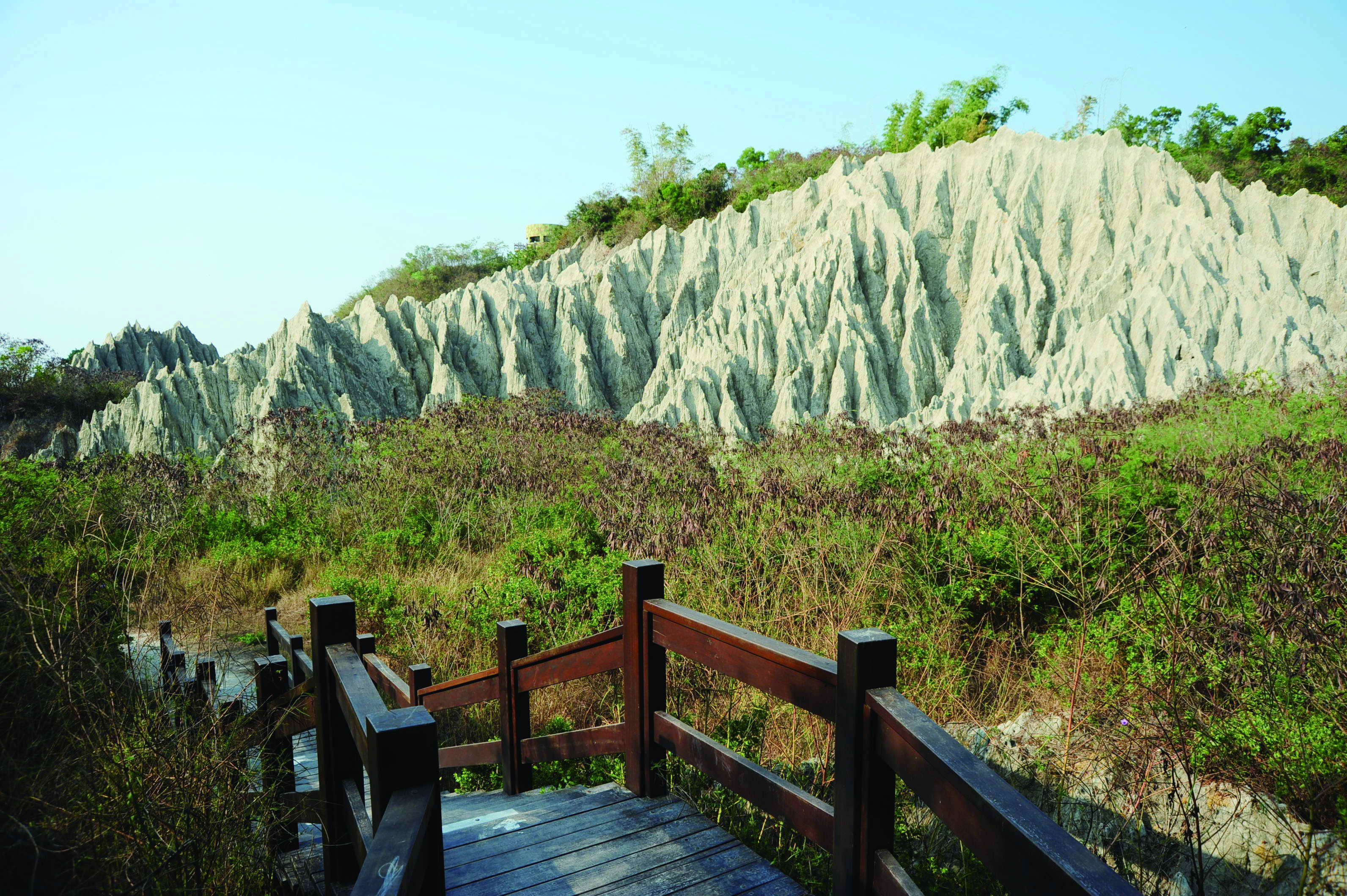 Located in Kaohsiung's Mituo District, Ta-di Mountain rises approximately 53 meters above sea level. Of Taiwan's various badlands, it's the one located nearest the coast. Gangshan Airport is east of the mountain, while the Taiwan Strait is to the west. To the south lies Zuoying's naval base, while TPC Hsinta Power Station is located to the north. Because of its advantageous geographical position, Ta-di Mountain became a restricted military area during the Japanese occupation period (1895-1945), and stayed until military control long after World War II. When the armed forces finally withdrew in 2006, the area was put under the jurisdiction of Mituo District Office. The office created a nature park, revealing the mountain's beautiful scenery to the outside world.
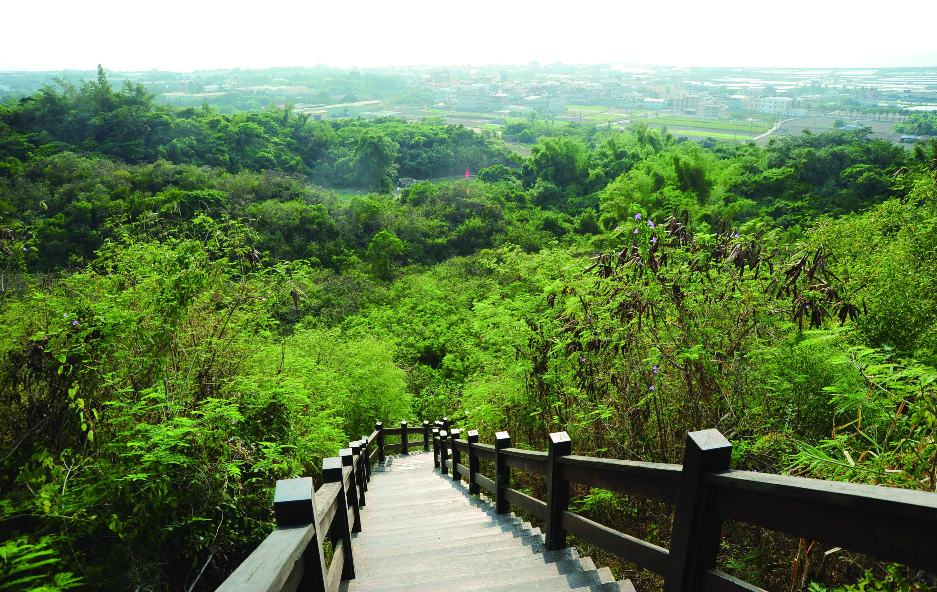
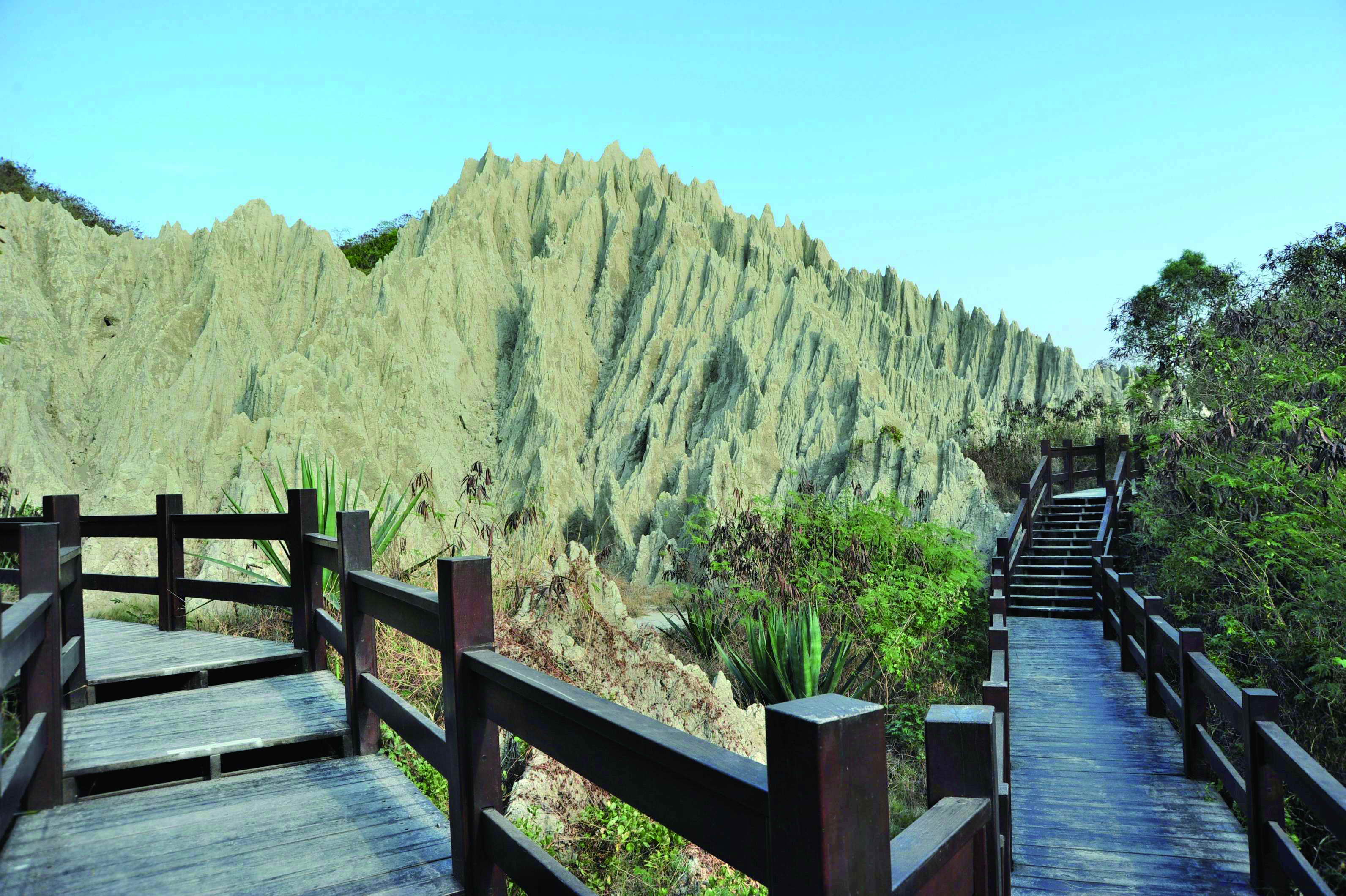
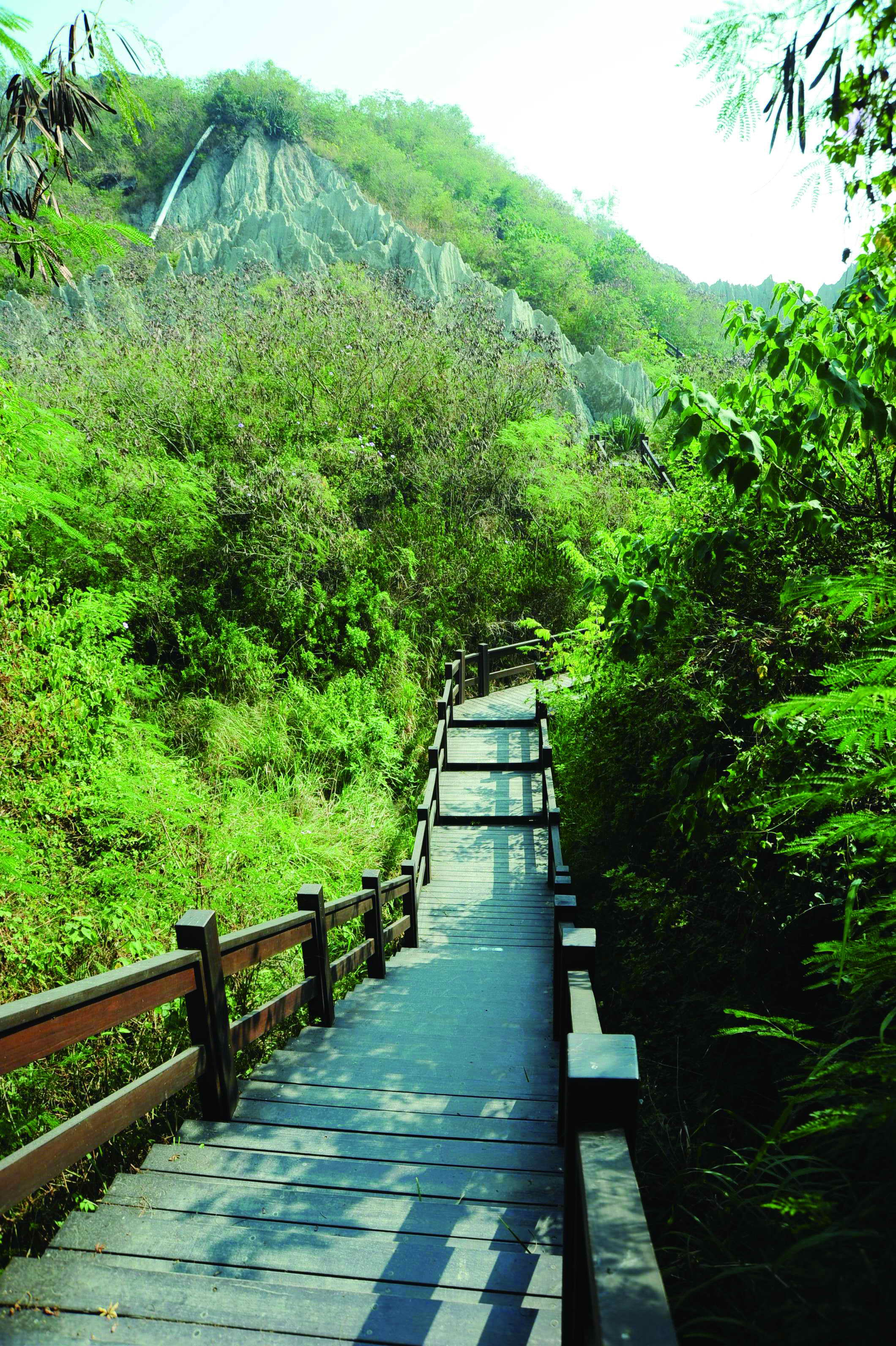 Many visitors come to Ta-di Mountain to enjoy the gorgeous sight of the sunset bathing the mudstone badlands topography. Attractions within Ta-di Mountain Natural Park include not only many hills bereft of vegetation and two small vents from which mud flows, but also hiking trails and a vast range of vegetation indigenous to Taiwan. Among them are century-old carambola trees. There are also date-palm trees, one of the four wonder trees of Taiwan, and these offer a surprising vista for visitors. It is also possible to walk past some of the military installations which reflect the area's history. With its diverse and rich landscape, the area is certainly worth visiting. First-time visitors may want to hire a professional tour guide through the Mituo Miluogang Cultural and Historical Association, which was established over ten years ago. Tour guides can share interesting facts. For example, they will introduce you to some plants that are actually poisonous, even though they have attractive fruit, such as highly toxic Yellow Oleander (Thevetia peruviana). Guides will also point that much of the land surrounding the military base was planted with sisal to prevent enemy airborne attacks, as the plants' sharp sword-like leaves would deter parachute landings.
Mr. Tsai Chih-hua, one of the association's senior guides, recommends a tour that takes 50 minutes to one hour. The best place to start is from the bunker, whose elevation provides vast, unobstructed views of the landscape. From there, visitors can go down the steps and soon view the badlands terrain. However, this route is long and steep, and quite challenging for visitors with weak legs. The best time to visit is April, that's when fish farms in the distance can be seen while the sun is setting; at that time of year, the sparkling, golden fish ponds shine beautifully. When the area was under military control, plans were made to block up the mud-spewing vents for security reasons. This was never done, however, and the two vents are still quite active. Mr. Tsai reminds visitors that the mudstone which makes up the terrain is the result of a geological miracle that took place thousands of years ago, so visitors are asked not to touch or climb the hills, as well as avoid doing anything that might damage the vents.
How to get to Ta-di Mountain?
(1)From central Kaohsiung, taking Taiwan Highway 17 and head north to downtown Mituo. There, one will see a sign pointing to Ta-di Mountain.
(2)Take bus 72 (Red Line) and get off at Fengci Intersection, then walk a few steps until you reach the mountain entrance. For information about where you can catch the bus, call the Bus Service Administration at (07) 746-2141.
彌陀漯底山
◎文/侯雅婷 ◎攝影/鮑忠暉
彌陀區漯底山海拔約53公尺,是全台最近海濱的惡地形山丘,東臨岡山機場、西臨台灣海峽、南臨左營軍港、北臨興達電廠。漯底山優異的地理位置,自日治時代起,即被規劃為軍事管制區,直到2006年撤哨,接管的彌陀區公所成立自然公園,外界始得一窺面貌。
 許多慕名而來的遊客,為的是一睹夕陽餘暉映在童山濯濯惡地形泥岩層山丘的美麗景致,但漯底山自然公園的精彩 ,除了廣為人知的多座惡地形山丘及兩座小型噴泥口,更特別的是,惡地形山丘的彼端,沿著登山步道,映入眼簾的是滿山翠綠的台灣原生種植物,從百年楊桃樹到台灣四大奇木之一的台灣海棗 ,讓人有柳岸花明又一村的驚喜,而散佈其中的軍事設施反映該地的歷史遺跡 ,多元而豐富的景觀絕對值得旅人造訪 。初次造訪漯底山的旅人,不妨預約當地成立10年之久的彌陀彌羅港文史協會專業導覽,由於漯底山部分景觀植物具毒性,比如黃花夾竹桃就是帶有劇毒的植物,可是其果實又極具吸引力;而在惡地形山丘旁一大片瓊麻,因為瓊麻尾端尖銳可防止敵人空降的威脅,原為軍事基地的漯底山基於安全考量廣植,像這些有趣的知識都可透過導覽員的分享 ,使旅人玩得盡興又安全。
 彌陀彌羅港文史協會資深導覽員蔡志華推薦的觀光路徑約須50分鐘至1小時 ,制高點碉堡是遠眺的最佳地點,開闊壯麗的大景一覽無遺,旅客也可從碉堡處順著階梯往下走,惡地形山丘的特殊景致就會出現在身旁,只是陡長階梯,對不勝腳力的旅人是一大考驗。最適合造訪雕堡的季節是在4月,日落時可以看見遠方的養殖漁池,在夕陽的照射下 ,波光粼粼的金色漁塭靜靜閃耀著。此外,噴泥口在軍事管制期為了安全的考量,曾試圖破壞噴泥口,但這兩座噴泥口仍持續活躍中。蔡志華呼籲造訪的旅人,惡地形泥岩層山丘是幾萬年累積成的奇景,請勿觸摸或攀爬惡地形山丘,也請勿破壞噴泥口。
漯底山交通指南
(1)省道台17往彌陀方向,過四維路口約50公尺迴轉山頂路,循著指標即可抵達。
(2)搭乘公車紅72號,至「分歧路口」站下車,再步行一段即可抵達。