Cycling around Cijin / 騎鐵馬遊旗津
Cycling around Cijin
Text & Photos by Luke
 When was the last time you rode a bicycle? No doubt most people will be scratching their heads to remember, given the speed with which we need to do things in this day and age - hence making bicycles a less favoured choice of transport.
However, Cijin offers the perfect place for such an activity. By just putting an extra NT$5.00 in the gates when boarding the ferry, you'll be able to enjoy everything Cijin has to offer while pedalling around the island.
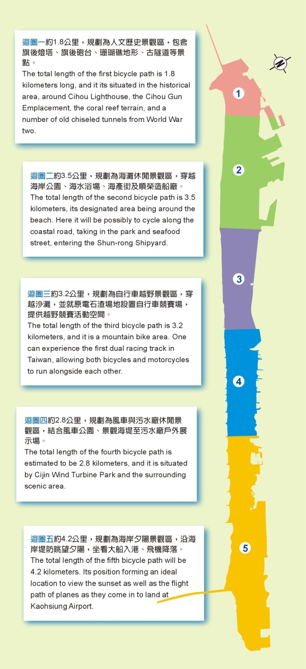
Kaohsiung City Government, Maintenance Office Bureau of Public Works has planned for five bicycle paths, both wooden and brick, to be implemented - three of which are to be completed by the end of February 2005. Built in a circular fashion, these five bicycle paths will run from the first harbour in Cihou to the second harbour at the Kao-tzi Tower, including some that pass by the historical area, the beach area, the windmill coastal area, the scenic area, and the sunset viewing platform. The bicycle paths vary in length allowing riders the chance to vary the distance they choose to ride.
◆ The beginning of a cycling journal
Taking the ferry to Cijin is an experience in itself. It's hard to find something more relaxing than standing on the deck of the ferry watching the boats roll into Kaohsiung Port. About 170 different types of boats regularly sail in and out of the Port not to mention the array of ships docked there in wait of their next navigation. Once the ferry arrives at Cijin Island, passengers alight with their bicycles, and then the fun of riding around the island begins.
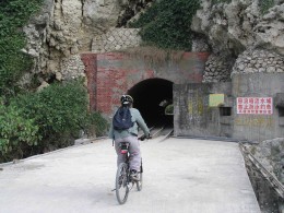
Whilst riding along Linggang Street in front of the Cijin Police Station, be sure to take a look at the many small alleys running off Tongshan Street, which is actually the first development site of Kaohsiung City. Once you arrive at the bottom of Cihou Mountain (48 metres above sea level), you'll be at the start of the first circular bicycle path, the historical area. The total length of this first path is 1.8 kilometres long and includes the Cihou Lighthouse, the Cihou Gun Emplacement, the coral reef terrain, and a number of old chiselled tunnels from World War II.
Riding up a slope of greater than thirty degrees in aspect in order to get to the Cihou Lighthouse or the Cihou Gun Emplacement challenges riders. For those who want a more leisurely ride, cycle along the bottom of the Cihou Mountain, which smoothly meets the First Harbour. Take in the view whilst riding along here, as there will be all kinds of ships weighing up to 20,000 tones right before your eyes. Further along, the view becomes even broader with the beach on one side and the trees high up on the coral cliffs on the other, not to mention the National Sun Yat-sen University being visible on the other side of the coast.
◆ A leisurely ride
The second bicycle path of 3.5 kilometres is yet to be complete, however riders will start from Cijin Hospital and ride along the beach, through the Coastal Park, along the Seafood Street, and into the Shun-rong shipyard. An option for mountain bike riders would be to ride into the Horsetall Tree area within the Shore Park. The exciting moments of this ride are surely to be traversing up and down hills, riding across fallen leaves, and cycling through forest areas.
◆ Enjoy the excitement
To satisfy those riders who enjoy the excitement of using the old factory area, the Cijin bicycle path has designed the first 'shared' racing track in Taiwan - for both bicycles and motorcycles.
Due to the old factory area being located at high terrain, it is unknown to many as a man-made sea-watching observatory. There is nothing better than looking out over the whole ocean with sunlight showering over the ships. Whilst up there, keep an eye out for a red warning sign reading "Danger! Sunken ship, strictly keep away", as the Kaohsiung Harbour Bureau erected this sign after a ship fell victim to the ocean.
Upon completion of the Cijin bicycle paths, visitors will be able to cycle from Jhongjhou to the Second Harbour rather than only staying around the Cihou area.
Rebuilt from the old factory, this wooden bicycle path is 3.2 kilometres long. After passing by the radar stations of the Coast Guard Administration, the path runs by the Windmill Park. Keep cycling for about 200-300 metres, and the Cijin Fishing Port and Dashantou Fishing Port are at your feet, not to mention the oldest Taiwanese mangrove area next to the Cijin Fishing Port. Bicycles can also enter the Kaohsiung Port Boats and Ships administration office area where cyclists can get a close-up look at the variety of patrol ships and working boats and how they are repaired.
From the Kaohsiung Port Boats and Ships administration office area, the two biggest privately owned shipyards in Taiwan - "Johg Shyn Shipbuilding Company" and "Cing Fu Shipbuilding" could be seen, as well as companies that specialise in larger yachts such as "Kao Ding" and "The Horizon Yacht Company". Furthermore, riding from the coastline next to the Chung Chou through the interchange area of the harbour tunnel towards the Second Harbour, one can see the ports of the big container ships - "Evagreen Marine Corp." and "Yang Ming Marin Transport Corp.".
Taiwan's most important and deepest port is 14 meters in depth. From the control tower in the Second Harbour to the other side of the coast, Hong Mao Harbour are always very attractive, no matter how many times you've seen them. A few hundred years ago, the area was used as a mullet-fishing village, but today it's a highly successful shipping port.
At the most southern part of Cijin Island is the 4.2 kilometre fifth bicycle path. Cycling along this path offers exceptional views of the sunset and of planes landing.
The five Cijin bicycle paths are a total distance of 15 kilometres, and they allow travellers the opportunity to always discover new and interesting sites while peddling around Cijin Island.
騎鐵馬遊旗津 文‧攝影/黃時 多久沒騎鐵馬了呢?在講究速率至上的時代,騎鐵馬已不自覺地躺在屋旁的角落。
走,只要多花五塊錢,丟進輪渡站的收費箱,找回最單純的快樂,在快速踩踏奔馳的同時,嘴角會忍不住向上揚起笑容,騎著鐵馬、逛旗津! 高雄市政府工務局養工處,分別以木棧道、人行磚等,規劃了五條單車騎乘路線,其中三條將在今年二月底完工開放,以迴圈概念,從旗后一港口到二港口的高字塔,透過五個騎乘迴圈,將旗津半島的人文歷史景觀區、海灘休閒景觀區、風車海岸景觀區、污水廠休閒景觀區、海岸夕陽景觀區,騎乘者可以自行調節騎乘距離,以最輕鬆的方式行進。 ★ 「自行車之旅」正式啟程
帶著單車搭渡輪只要多花五塊錢,站在渡輪的甲板上,遠望高雄港這個平均一天有一百七十艘各式船舶進出的港埠,是件愜意的事,高雄港內航道的泊區,可見大輪船已歇腳搫泊,安靜等待下次出航,待渡輪靠向旗津輪渡站,單車客的「旗津環島海景觀光自行車道之旅」正式啟程。 沿著旗津分駐所前的臨港街道騎,通山街的小巷是高雄市的發展起點,來到海拔四十八公尺的旗后山下,自行車道的第一個迴圈正式開始,1.8公里的人文歷史景觀區,包括了旗后燈塔、旗后砲台、珊瑚礁地形與日據時代因應二次大戰開鑿的古隧道。 相較於騎車上燈塔或者古砲台,騎乘者面對著30度以上的斜坡的挑戰,單車客也可以選擇沿旗后山下,平緩地繞向高雄港一港口,二萬噸以下的各式船舶就在眼前幾公尺處滑過,轉個彎,視野瞬時變得開闊,一邊沙灘一旁則是沿著旗后山珊瑚岩壁攀長的綠樹,對岸就是中山大學西子灣,單車木棧道緊臨山腳修築直通古隧道內,踩踏間有著海天一角的景緻。 ★ 踩踏單車 享受悠閒
旗津單車道總長3.5公里的第二個迴圈尚未發包,但騎乘者仍可以從旗津醫院開始,進到海水浴場,穿越海岸公園、海產街及順榮造船廠,登山越野單車可以試試騎進濱海公園內的木麻黃區,高高低低的土丘,騎車忽上忽下衝刺,有越野的刺激,而滿地落葉輕騎前進,體驗在山間林道騎乘的悠閒感覺。 ★ 體驗越野的刺激
為了體貼喜歡刺激的單車旅遊者,旗津單車道也將原先電石場,設計成為全台第一座單車與機車共用的競賽場。 由於地勢相對高聳,電石渣場是個很少被人發現的人造觀海台,眺望海平面全無遮攔,陽光灑在外海泊區的輪船上,宜人無比,由於幾年前一艘輪船在此區水域沈沒,高雄港務局因其制高特性,還立了「沈船危險、嚴禁靠近」的紅色標誌。 旗津自行車道在修築後,讓以往只佇足停留在旗后一帶賞玩的旗津旅遊行程,能隨單車道的路線,向中洲乃至二港口縱貫延伸。 由原電石渣場改建的自行車越野區,總長3.2公里的木棧道,經過海巡署雷達站,直接連結旗津國中前的風車公園,再經過約200~300公尺就到達旗津漁港、大汕頭漁港,而台灣最老的紅樹林群也在旗津漁港旁,單車也可繞進高雄港船舶管理所,這裡有各式的海巡艦、工作船舶,遊客們可在此近距離觀察修築漁船的工人為船體重新上妝。 想要一睹台灣最大的民營造船廠「中信」與「慶富」,專門建造大型遊艇的「高鼎」與「嘉鴻」,看到穿梭洲際的巨大貨櫃輪,必需再努力踩踏,由中洲污水處理場旁的海岸,經過過港隧道的交流道,騎在戰備道上往鄰近二港口的防風林走,一旁是「長榮」與「陽明」的貨櫃碼頭。 台灣最重要深度達負14公尺的碼頭,從二港口高聳的傳播交通指揮塔台坡堤,對岸的紅毛港與台電運煤碼頭,不管來幾次同樣宜人,幾百年前因捕烏魚形成的聚落漁村,而今已轉變成為巨輪的泊靠港。 半島的最南端,總長4.2公里的迴圈五單車道,沿海岸坡堤眺望晚霞,看著飛機在此向下滑向機場。 |